/>On May 6 I left for a motorcycle trip to California. I headed west on I-70 on a rather cool morning in the low 60’s and then the temperature rose to 84 in Denver. I ran into a little rain before I reached Denver so I had my rain gear on in Denver. It wasn’t long though when I headed up the mountains that it cooled off quickly to the upper 30’s with some light snow. After I went through the Eisenhower Tunnel there was a lot of snow piled up. I stopped at a rest area near the Vail summit and the snow nearly had the rest rooms covered. I forgot to take a picture of it.
I arrived at Joe & Sandi Suther’s in Eagle, CO about 5:30 and they hadn’t received my e-mail that I was coming. I was welcomed anyway and spent the evening visiting. So the first day I made 693 miles.
I left by 7 AM the next morning with would turn out to be my usual departure time on this trip. Joe leaves for work at 7 AM also. I usually am an early riser. Day two found me heading west on I-70 to just past Green River, UT where I headed southwest on hwy 24 to Hanksville then west to Torrey where I picked up hwy 12 and headed south. Temperatures varied from 38 to the upper 70’s. It seemed like I was either taking clothes off or putting some on.
The first scenery I came to was the Capitol Reef National Park. There were unique rock structures with varied colors. Each area I came to was different and had its own beauty.
I continued on through Grand Staircase-Escalante Park and this had some very deep canyons and in one area for about ¼ mile I rode on a ridge just wide enough for the road with a deep canyon on both sides. I took a picture but you have to be there and see it to get the full effect. Pretty creepy! When I came over a summit it started raining, then turned to heavy snow which stuck to my windshield. I lowered it down as far as it would go then looked over the top and wiped the snow off my face shield with my hand. My windshield has an electric motor that will raise & lower it. The road did not get slick and then started to rain again.
I bought a new SLR Nikon camera about a month ago and it takes wonderful pictures. On this trip I took 283 pictures and never had to charge the battery. The regular lens is an 18mm to 55mm zoom and I have another lens from 55mm to 200mm but I only used the larger one at one area while taking pictures of the sea lions.
This night I stayed in Tropic, UT and after many picture stops I still made 507 miles. I had my Jack Daniels and went next door for a pizza and will hit the bed early tonight.
It rained several times during the night and I could hear the wind blowing. I got up about 6:30 and had toast and coffee at the cowboy motel. The rooms were rustic with wooden shutters instead of curtains. Many of the people eating were with a group and I think they were speaking French, probably from Quebec. I was surprised this whole trip of the number of people traveling and the number of foreigners. Once I tried to talk with a young guy driving a rented motor home and he was from Germany and was only able to understand he had rented it in San Francisco. There were large numbers of rented motor homes throughout this trip. There were also large numbers of tour buses and one had Chinese writing on it.
It was about 40 degrees this morning and I only went a few miles when I headed into Bryce Canyon. I saw deer, antelope, turkey and several bluebirds. I was too early and there wasn’t anyone at the gate when I went in. It costs $12 but I have a Golden Age Passport that you can buy when you are 62 and it allows access to all the National Parks free. I used it five times on this trip. I only went a short distance into the park and the ground was white with fresh snow.
The further I went into the park the more snow there was and it was about 4 to 6 inches of fresh snow and the trees were just covered. It made for some great pictures and I took a lot of them. The road was wet and steaming and some places still had snow on it. I took a time exposure of me standing in the snow. It is easy to do with this camera so I was able to get some pictures of myself on this trip.
After leaving Bryce Canyon I stopped for breakfast about 10AM. I then headed on for Zion National Park.
I really liked all the unique rock shapes and layers. One place looked like a checkerboard. There was a long tunnel in the park that was 1.1 mile long. A lot of people were visiting the park even though it is early in the season.
After leaving the park I headed south east towards Lake Powell and Arizona. On this stretch of road within 10 miles I had two cars that were passing others coming toward me, that forced me to slow down and the second one pull over to the right to avoid a head on collision. I know they had to see me as I had my lights on, they just didn’t care. I shook my fist at both of them.
I stopped at Glen Canyon Dam on Lake Powell.
The lake appears to be 50 to 75 feet low. I was quite a ways from the water and the lake didn’t seem that impressive to me but I know it is quite large. I took this information from their web site: Lake Powell - more than 400 feet deep, 150 miles long and nearly 2,000 miles of shoreline
The current elevation of Lake Powell (May 10, 2008) is 3,597.13 feet. 43.7% of full pool.
After I left there I headed southwest to Grand Canyon.
This is very desolate county and home to the Navajo Indians. I don’t know what they live on unless it is from all the stands along the road where they sell jewelry to tourists. I mostly rode through the park and only took two pictures. Mary and I visited there many years ago. I had a deer run out in front of me and I about hit it. I tried to find a room there but they wanted $160 so I left the park and headed south a few miles and found one for $120. I had intentions of going back to the park the next morning but changed my mind. I called Betty Marcotte and told her I would probably there tomorrow.
So on May 9th I headed west across the Mohave Desert.
Not much to see here but the temperatures was in the mid 80’s which was a treat.
I thought they would be much higher around Needles, CA. I had to buy gas once for $4.29 a gallon! As I neared Los Angeles I stayed to the north as I had programmed in my GPS. The traffic was not bad but then I arrived on a Friday about 3:30 before their rush hour. I arrived in Santa Paula at Don & Betty Marcotte’s, my aunt & uncle, about 4PM on Friday.
I wasn’t sure how long I would stay but ended up not leaving until 10 AM Monday. I had not seen them since 1981 when we had a family reunion in Superior, NE. We had a great visit and caught up on old times. I was quite interested listening to them tell of some of their life happenings. Don took me to the coffee shop with him two mornings and I met some of his friends and dropped me off at church on Sunday. After coffee we would go back to their home and Betty fixed breakfast. Betty has many nice flowers, roses, a vegetable garden and some black raspberry bushes. She makes some excellent jelly from the raspberries and she sent two jars home with me. I guess I will share it with Mary too! Betty said some she has given as gifts were hidden from the spouse so they wouldn’t have to share their treasure. There are orange trees right across the street and I took a picture through her front window with the trees in the background.
The City of Santa Paula, California is located 65 miles northwest of Los Angeles and 14 miles east of Ventura and the coastline of the Pacific Ocean.
Santa Paula is the geographical center of
Ventura County, situated in the rich agricultural Santa Clara River Valley. The City is surrounded by rolling hills and rugged mountain peaks in addition to orange, lemon and avocado groves. In fact, Santa Paula is referred to as the "Citrus Capital of the World."
On Sunday we went to Ron and Shelley Barta, their daughter and my cousin, and visited with them and their two children Clint and Cody. On the way there we stopped at a Japanese strawberry market and Betty bought a flat of beautiful strawberries. These were picked fresh that day and one lady was wiping each strawberry off before placing them in the boxes. They tasted great and were so sweet, not like the ones we buy here in the store. Ron and Shelly fixed a wonderful lunch with steak, chicken, shrimp and roasting ears on the grill. I had a good visit with Ron and toured their nearly finished home, his office, shop and garage. Ron has a construction company and has several hired persons. They have a wonderful home and family.
We then went to the Ronald Reagan Library and toured it. This was Mother’s day and we arrived there after the big rush. They had a large area by Air Force One sent up for a brunch and it looked like they had served a bunch.
I left Monday morning and headed up the coast on hwy 101 and then CA 1. There was quite a lot of traffic the first 50 miles then it cleared out. It was cool, only in the mid 50’s and only warmed to 65 if I was inland. I saw many crops, not all of which I could identify. I saw strawberries, cabbage, broccoli, lettuce, artichokes, oranges, lemons, almonds and flowers.
California has been the number one food and agricultural producer in the United States for more than 50 consecutive years.
More than half the nation's fruit, nuts, and vegetables come from here.
California is the nation's number one dairy state.
California's leading commodity is milk and cream. Grapes are second.
California's leading export crop is almonds. Nationally, products exclusively grown (99% or more) in California include almonds, artichokes, dates, figs, kiwifruit, olives, persimmons, pistachios, prunes, raisins, clovers, and walnuts.
From 70 to 80% of all ripe olives are grown in California.
California is the nation's leading producer of strawberries, averaging 1.4 billion pounds of strawberries or 83% of the country's total fresh and frozen strawberry production. Approximately 12% of the crop is exported to Canada, Mexico, United Kingdom, Hong Kong and Japan primarily. The value of the California strawberry crop is approximately $700 million with related employment of more than 48,000 people.
California produces 25% of the nation's onions and 43% of the nation's green onions.
Gilroy, California, "Garlic Capitol of the World," has hosted 2 million at the annual Gilroy Garlic Festival.
I really couldn’t get close to the ocean until Morro Bay then hwy 1 stayed pretty much along the coast. Most of it was slow going with some traffic and many curves, mountains and pull offs for pictures.
It is a very scenic drive with the mountains on the east and ocean on the west. Much of the time the road lead up the mountain and then back down, a dream ride by motorcycle. Some places the wind was very strong. At San Simeon is the Hearst Castle and I went to the welcome center. The large parking lot was nearly full and there were lots of tour buses. I can’t imagine what it would be like during tourist season. The tour is about 2 hours for $20 but I didn’t go because of all the equipment on my motorcycle, like the GPS, satellite radio, camera lens, etc. I was afraid it would be stolen. The lady said it is 5 miles up to the castle and I could see it on top of the mountain.
Further up the coast there were elephant seals and I saw lots of them, probably several thousand. For more information go to:
http://www.bigsurcalifornia.org/elephant-seals.html
I came on up the coast to Castroville then headed east towards Fresno. I stayed in Hollister in the Cinderella Motel which was one of the nicer ones I stayed at and only $48. Gas today ranged from $3.87 to 4.12 and some places that were in the same town. Some are trying to rip us off.
Today I went from Hollister to Oakhurst and it seemed like a lot of hard riding and only 376 miles. I went to Fresno then took 180 up Kings Canyon to the Sequoia National Park so I saved another $12 today. The trip to Kings Canyon was interesting in that it went through a lot of farm ground and tree farms, mostly oranges. On the way to Fresno I stopped and took a picture of an almond tree and it was loaded with almonds. I saw olive and walnut trees also. One nice thing about being on the BMW or any motorcycle, are the smells, some good and some not so good. Yesterday I could smell the ocean and today the strawberries, onions, cabbage, flowers, flowering trees, cut alfalfa, smoke, and the fresh air. Of course the unpleasant odor such as dead animals, feed lots and cattle trucks are not so nice. You can also feel the temperature changes like at the bottom of a hill being cooler than at the top.
I saw some really big trees with the largest being the General Sherman. Here is its size: Feet Height above Base 274.9 Circumference at Ground 102.6 Maximum Diameter at Base 36.5 Diameter 60' (18.3 m) above base 17.5 Diameter 180' (54.9 m) above base 14.0 Diameter of Largest Branch 6.8 Height of First Large Branch above the Base 130.0 Average Crown Spread 106.5
They were also making some controlled burns in the area so in places there was smoke. The mountains roads are very steep in these parks and that is where a motorcycle works great since I can shift down. At the bottom of the mountain when you get to the dry arid land there is Lake Kaweah and it was full as some of the roads and trees were under water.
I was looking for the BMW dealer in Fresno and set the GPS to take me there, which it did. However they had moved and left the new address in the window so I programmed in the new address which was quite a distance. I found it and purchased rear brake pads and a PIAA driving light as I had one not working. I was then going to head up to Yosemite National Park so I programmed that into GPS to get out of Fresno. It is sure a big help when you are trying to find your way. I have ear buds so I listen to Sirius satellite radio and then “Lola” cuts in to tell me where to go. I took hwy 41 to Oakhurst.
It was very hot today in Fresno and any time I was not in the mountains. It got up to 90. As I headed north out of Fresno I got into road construction and was lucky I was the last one to go through before they stopped traffic since it was backed up for a mile the other direction. It seemed like for this early in the year there was a lot of road construction. I made it to Oakhurst and found a motel. After unloading I decided to change the brake pads before cleaning up. I had a little problem changing them but not bad. It probably took a half hour. I put in the new bulb and that did not fix the problem so it must be a wire. I would have to take the fairing off one side and decided to wait until I get home.
I talked with Mary to see if I should head home and we agreed I would wait another day or two. I really wanted to go back to the coast and go further north. Once I decide to head home it will take three days.
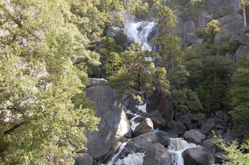
On Wednesday May 14 I went from Oakhurst to Gualala. I went through Yosemite National Park so I saved another $12 today. There were not many people in the park since I left at 7 AM again. I took some great pictures of Bridalveil Falls.
This was the prettiest falls I have seen. It made the trip through the park a grand adventure.
I ran into construction again. I wanted to avoid San Francisco since Mary & I are going there in August so I took hwy 120 all the way to Stockton. I came to Oakdale and I think that is where the California happy cows are. I went through the California Delta area where there is farming of corn, alfalfa, wheat, and other crops. The Sacramento River is huge. The California Delta is located roughly between Sacramento on the north and Stockton on the south and encompasses about 1,000 miles of waterways.
The main contributing rivers are the Sacramento River, coming in from the north, and the San Joaquin River, coming in from the south. Other rivers feeding into the two major rivers include the American River, the Mokelumne River, the Cosumnes River and the Calaveras River. Before these rivers empty into the Pacific Ocean through the San Francisco Bay, they pass through some of the best boating waterways in this country, if not the world. The California Delta is a labyrinth of sloughs with names like Potato Slough, Whites Slough, Snodgrass Slough, Lost Slough, Georgiana Slough, Steamboat Slough, and many, many more. As one explores these watery avenues, vistas of vine-covered trees, blackberry brambles, or tule grasses appear at almost every turn. It truly is a boater’s paradise.
Once again it got very hot. At Stockton I headed north on I-5 to hwy 12 which went through the Napa and Sonoma wine country. There it was 100 degrees and lots of traffic. I finally got to Santa Rosa and headed west over the mountains. Within 30 miles the temperature dropped 40 degrees and really felt good.
I stopped at Sonoma Beach and took some pictures and talked with a family from Stockton and they had come to the beach to get away from the heat. They said it was supposed to be hot again tomorrow. He said it gets very hot inland during the summer so they come to the beach often.
I started up the coast at Bodega Bay.
This was a beautiful ride with a very winding road and great scenery. While I was eating dinner tonight at a restaurant over looking the ocean I saw a whale blowing. Being a flat Lander I didn’t say anything because I thought I might have imagined it but soon others saw them again so I guess I wasn’t seeing things after all.
On May 15 I went from Gualala along the coast to Winnemucca, NV in the high desert.
After leaving Gualala I stopped at Point Arena to view an historic lighthouse.
On the way in a small deer was in the road and I stopped and took its picture then it crossed the fence and I took another.
I took several pictures on the way in of the fog and landscape and saw another deer in the distance.
The ocean was really pretty here. I continued up the coast and decided I had seen enough of the coast so I headed east on hwy 20. This was a good choice for a road since it was a good road all the way across California. There is a very large lake, Clear Lake, which I rode around. Many people have lake side homes right next to the water. It was a very pleasant area.
Around Yuba City the temperature hit 101 at 11 AM. Then I got into the Tahoe National Forest and it cooled to the 80’s and even 70’s at Truckee and Donner Summit which was 7,239 ft. CA 20 turned into I-80 and I really expected Nevada to be hot but the temperatures stayed in the mid to lower 80’s. I stayed in Winnemucca and the elevation is 6,600 and is called the high desert. There is snow in the mountains. I-80 headed north from Reno and will exit Nevada at Wendover. I probably could have gone on up the coast into Oregon and came down hwy 140 and it wouldn’t have been much further, but that is hindsight!
On May 16 I went from Winnemucca, NV to Cheyenne, WY which is 827 miles. When I decide to start home I usually don’t fool around. It was a hard day’s ride from 7 AM to 7 PM Mountain time for 11 hours.
The only time I had seen the Great Salt Lake was flying into Salt Lake City so this was a new experience driving across the salt flats and seeing the salt lake. There were warning signs about drowsy drivers and to be alert for them. It was pretty boring and would be easy to go to sleep. I also noticed when was going out across the Mohave Desert when I headed west that the further west you went the more areas I seen where cars or trucks had left the road, probably from going to sleep. The weather was great with a high temperature of 77 and a low of 58 here in Cheyenne. There was little or no wind with clear blue skies and that makes for a great ride. I called ahead for a motel in Cheyenne so I could ride longer. It did sprinkle near Cheyenne and there was a rainbow but by the time I pulled over to take a picture it was gone. There is still a lot of snow in the mountains of California, Colorado, Nevada, Utah and Wyoming. In Wyoming along the roads where the snow fences are, the snow is still piled up. Sure saw a lot of antelope in Wyoming, probably several hundred. Other times, when I went though in the summer I did not see as many.
In California there were signs stating, “Speed kills Bears” and in Utah there was an area warning of, “Frequent bear crossing for the next 6 miles”. I didn’t see any though. East of Salt Lake City must have been where the winter Olympics were held a few years ago as most of the area was new and the ski slopes were right there. Twice today I went over 250 miles without stopping. The speed limit is 75 so I set the cruise on 80.
On Saturday May 17 I arrived home about 4:30 coming from Cheyenne. I came east on I-80 into Nebraska to US-183 where I came south through Phillipsburg and down to I-70. It was good weather again but a little windy. I was glad to get home after being gone for 12 days and 5,215 miles. I averaged 48.92 mpg and spent $400 for gas, $442 for lodging, repairs $135, and $182 for dining. Total spent was $1,259.
It was a great trip and I enjoyed my visit in Eagle, Colorado with Joe & Sandi Suther and in Santa Paula with Don & Betty Marcotte. Thanks to both families for allowing me to spend some time with them and for boarding me. I saw country I had never seen before and could have spent a great deal more time in California. There is a lot to see there and I have a much better appreciation for California now.
To view the rest of the pictures look on the right side under pictures California trip.